By Bill Walker
The Florida Peninsula is a limestone plateau formed many millions of years ago when the area was a warm, shallow sea. Millions of years of deposits from small sea creatures make up the limestone, which is several thousand feet thick.
Basic Geology
Limestone, a carbonate rock also known as calcium carbonate, is formed in warm shallow seas. As all the tiny sea creatures die, they sink to the bottom and their bodies build up on the sea floor. Limestone is basically the fossilized and calcified remnants of these creatures. Geologically speaking, Florida limestone is very new. It is only 50-60 million years old, as compared to say the limestone in Kentucky, which is about 430 million years old. Florida limestone is very soft, very white, and contains many fossils. Central Florida limestone is known as the Ocala Group (made up of the Inglis Formation, the Williston Formation, and the Crystal River Formation, but that is probably more than you wanted to know.) This is the principle type of limestone in the area.
Sitting on top of the bedrock is a clay layer named the Hawthorn Formation. Made up of deposits from ancient rivers from the Appalachian Mountains, this clay (some people know it as gumbo clay) is a grey/greenish in color and very tacky. The clay layer is impervious to water, which means that water cannot seep through it to the underlying bedrock. Also, water, under pressure from the aquifer, cannot seep back out.
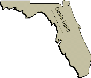
The Hawthorn Formation is very thick in some places. These areas are generally devoid of karst features (such as sinkholes, springs, and caves.) In some places, though, like along the Ocala Uplift (see below), the clay and soil layers are very thin. In these areas, the limestone bedrock is very close to the surface. These areas exhibit many karst features including caves. SEE MAP
The Ocala Uplift
The Ocala uplift is a very important geologic feature in Florida. It stretches all along West Central Florida from Brooksville in the south to Live Oak in the north. It runs parallel and west of I-75 and is characterized by high, rolling hills. This is horse country. This is also cave country.
 The Ocala uplift has been weathered by erosion over the last few million years, and the confining layers of sand and clay have been removed by the elements. Therefore, the limestone bedrock is very close to the surface, within 0 to 50 feet. This allows many of the cracks, crevices, and caves in the limestone to become exposed. The Ocala Uplift is home to the majority of dry caves in Central Florida. Most Central Florida caves are located in the Western sections of Alachua, Marion, and Citrus Counties. West and East of the uplift, the limestone gradually sinks and is buried by over a hundred feet of sand and clay. In Marion County you won’t find any dry caves east Ocala.
The Ocala Uplift is also a major recharge zone for the aquifer. The area is mostly devoid of surface water because much of it is diverted under ground through all the cracks and caves below the surface. Compare Eastern Marion County with all of its lakes and rivers to that of the horse farms of Western Marion. Also, you won’t find many springs along the uplift. The springs are located to the east and west of the uplift. https://www.floridacaving.com/basic-central-florida-geology/Consider Marion County again with Rainbow springs in the West and Juniper Springs in the East. The water that falls along the uplift is quickly channeled underground and generally reappears to the west and to the east of the uplift.